How a shifting Nile landscape shaped the rise of the ancient empire of Kush in Sudan
The ancient Kush city of Jebel Barkal rose up in the Nile River Valley starting around 2000 BCE. New research dug deep to learn more about what this landscape was like over the past 4,000 years.

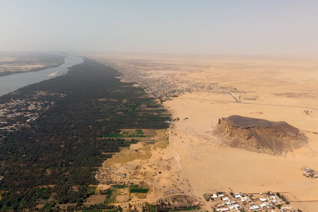
When I first became co-director of an archaeological project at Jebel Barkal in northern Sudan in 2018, I was amazed by the site’s pyramids, temples and palaces. It had been an urban center in the ancient empire of Kush, which dominated the Nile Valley off and on for over 2,000 years, from 2000 B.C.E. to 350 C.E.

I was far from alone in admiring the ruins – European and American travelers have visited and archaeologists had documented the site for the past two centuries. More recently, Jebel Barkal was recognized as a UNESCO World Heritage site in 2003.
But researchers still know so little about the ancient city and its residents, particularly compared with other ancient cities of Egypt, Assyria, Greece and Rome. Where did nonroyal people live? What did they eat? We don’t even know how they got their water, since the site is about a mile away from where the Nile flows today. Could there have been a nearby channel of the Nile that has since filled in? What was this landscape like when Jebel Barkal was a major urban center? More broadly, how did changes in climate over the past 4,000 years affect the growth of the city?
Some of these questions can be studied by a field called geomorphology, the study of how the Earth’s surface changes, especially by erosion. To learn more about how the landscape around Jebel Barkal had changed over millennia, I invited two Dutch geomorphologists, Jan Peeters and Tim Winkels, who had previously worked on Nile landscapes in Egypt, to come to Sudan to design a study.
The Nile as a source of life

The Nile floods at the end of every summer, as rains from the Indian Ocean monsoon fall on the highlands of East Africa. The ancient historian Herodotus famously called Egypt “the gift of the Nile” because in Egypt. the rich silt the floods deposited every year made for fertile fields. Egyptians retained the floodwaters in ponds and basins to use later for irrigation.
Upstream in Sudan, however, the underlying geology and geomorphological setting is different. This stretch of the Nile is interrupted by bedrock outcrops that break the flow of the river by what are called cataracts: islands, rapids and even small waterfalls.
The Nile also cuts more deeply into the bedrock and is more confined to the riverbed in Sudan than in Egypt. The floodplains here are generally more limited. As a result, it’s harder to hold onto water to use for irrigation after the annual flood has passed.
Our team wanted to understand how the ancient city interacted with the Nile and how that relationship developed through time as climate and the local environment shifted. Our recent study, published in the Proceedings of the National Academy of Sciences, looked at how the Nile channel and floodplain and Jebel Barkal evolved over centuries.

To learn about the ancient landscape, we collected 26 sediment cores, averaging 26 feet (8 meters) in depth and 3 inches (8 centimeters) in diameter. These cores are like time capsules that preserve the stacked layers of sediment from Nile floods that accumulated gradually over thousands of years. Connecting the dots, 17 of our cores formed a line across the Sudanese Nile valley. A second group of nine cores focused on the area where the ancient city developed.
The work was physically challenging, due both to the unrelenting Saharan sun and the depth of the sediments. Together with a team of five local men, we spent weeks drilling the cores using hand augurs and a gas-powered drill.

Hatim Awad Abdullah was this group’s energetic leader. He had his own interest in the history of Nile flooding, in part because his father and grandfather had told him that the river used to flood different areas than it has in more recent times. Our conversations with Hatim were part of a broader effort on our project to engage members of the local community, and they informed and enriched our understanding of the landscape. Other projects in Sudan have taken similar steps toward community engagement.
Extracting info from the sediment layers
Once our team had extracted the long sediment cores, we laid them out in sections so the geomorphologists could document what was in them at different levels. Sediments at the top of the cores are more recent, those lower down come from earlier in time.

Finer clays, silts and coarser sands would all have been deposited by different processes. Gentle flooding from the Nile could have carried some of these particles. More turbulent water draining from the desert via seasonal drainage channels called wadis might have brought others. By working from the deepest, oldest parts of the core samples to the ground surface, the geomorphologists could reconstruct a sequence of flooding and sediment deposition over thousands of years.
Our next step was to try to establish dates for when the sediments at different levels were deposited. One set of information came from fragments of ancient pottery found in some of the cores. Our team’s ceramic specialist, Saskia Büchner-Matthews, was able to analyze these small pieces and could often tell by their color, texture and shape when they had been made.
Another line of evidence relied on a technique called optically stimulated luminescence dating. By measuring the energy given off by minerals in the sample, like quartz grains, this amazing technique establishes when a sediment was last exposed to light. In order for optically stimulated luminescence dating to work, the samples need to be kept in the dark, so we had to be careful that our sediments were collected in black opaque tubes. Our team member Liz Chamberlain did this labor-intensive analysis in a specialized lab at Wageningen University in The Netherlands.
Our results show, first of all, that there had been an ancient Nile channel close to Jebel Barkal, but more like 10,000 years ago – millennia before the people of Kush built their city here. By the time the site was first occupied around 2000 B.C.E., that channel had long since filled in. So we still don’t know for sure how the people of Jebel Barkal got their water, but it’s clear that the Nile wasn’t running right next to the city.

The data also shows that the floodplain began to build up from regular Nile flooding starting around 2000 B.C.E. This process continued until the early 20th century, when upstream dam construction altered the Nile’s natural flood regime. That gentle accumulation of fertile soil in the floodplain, which the people of Jebel Barkal used as agricultural fields, encompasses nearly the entire ancient history of the city.
The cores our team drilled show that the city grew during a time of abundant rains and productive, predictable Nile flooding that provided fertile soil for agriculture. It doesn’t look like local climate change is the reason Jebel Barkal eventually went into decline.
Our scientific results lend new weight to an inscription of the ancient Kushite king Taharqo, who ruled over both Nubia and Egypt from about 690-664 BCE. It records a gentle and particularly abundant flood in the sixth year of his reign.
“When the time for the rising of the Inundation came, it continued rising greatly each day and it passed many days rising at the rate of one cubit every day.
"It penetrated the hills of South-land, it overtopped the mounds of North-land, and the land was (again) Primeval Waters, an inert (expanse), without land being distinguishable from river. …
"Every man of Nubia was inundated with an abundance of everything, Egypt was in beautiful festival, and they thanked the god Amun for His Majesty.”
This research has been particularly satisfying for me because it helps build a richer picture of life in ancient Sudan, comparable in depth and detail to what we know about other ancient civilizations.
Geoff Emberling has received funding from the U.S. Department of State (through its Ambassadors Fund for Cultural Preservation), the National Endowment for the Humanities, National Geographic, and private donors including Kitty Picken, Steve Klinsky, and Roger and Ann Cogswell. In addition to his position at the University of Michigan, he is a board member of the International Society for Nubian Studies and Secretary of the American Sudanese Archaeological Research Center.
Read These Next

5 lessons from 20 years of climate surveys: Political party matters, but it doesn’t explain everythi
Why would a young Republican back solar but reject a carbon tax? Twenty years of survey data shows climate…

Time for a clock change? Congress considers daylight saving time … again
A bill now being considered in the Senate would make daylight saving time permanent, but research suggests…

More testosterone won’t make a better soldier or a tougher man – aggression and strength drive T lev
Defense Secretary Pete Hegseth is requiring service members to screen for low testosterone levels. Ironically,…