Mapping cemeteries for class – how students used phones and drones to help a city count its headston
Cemeteries are a treasure trove of local history and family connection. Technology and ingenuity have made mapping them easier.

If you told me a decade ago that I’d become an expert in mapping cemeteries, I would’ve laughed and been very confused about the dramatic turn my professional life must’ve taken at some point.
I’m an environmental scientist who specializes in geospatial technology, which involves analyzing the Earth and how geography plays a role in human societies. I use these tools in my work to map conservation planning, food deserts, trail systems and green space accessibility.
For the past 20 years I’ve been overseeing Miami University’s Geospatial Analysis Center, building relationships with local cities, counties and companies. I started pairing my classes with outside partners to do mapping and analysis work. Some of the work my students most enjoyed was mapping small local cemeteries in and around southwest Ohio. The projects allowed them to gain experience with collecting data in the field and provided a human connection to the data.

Then in 2020, the local cemetery association of Oxford, Ohio – which owned and operated the area’s largest cemetery, spanning over 40 acres – fell upon financial troubles and dissolved. This meant the city was now solely and fully responsible for the management and maintenance of this historic and active cemetery. And it was provided only old paper maps and stacks of interment cards that listed names, dates and funeral homes. The assistant city manager reached out to see whether there was a way we could help with mapping the cemetery and transitioning from all-paper to digital resources.
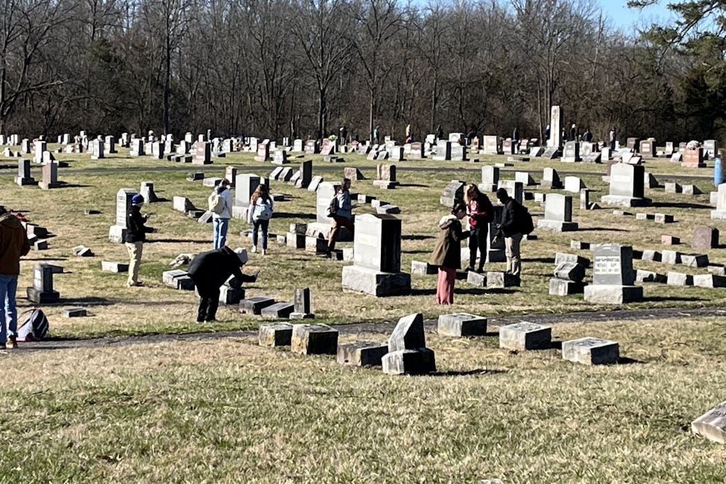
Thus began a yearlong adventure in harnessing the efforts of over 50 college students to figure out how to map a cemetery with over 6,000 headstones and virtually no records. What I didn’t anticipate was the newfound connections students would develop to the college town they call home.
Old school cemetery mapping
Traditional mapping methods would have us divide and conquer: We’d go out to the cemetery with multiple GPS units and mark a point on each headstone. While at the cemetery, we’d also take a photo of the headstone and write down its information – such as name and dates of birth and death – in a notebook.
Back in the office, we’d then combine the data from all our GPS units with the handwritten notes and photos. The final dataset would include the location of the headstone, all information on the headstone and a reference link to a photo.
This process took roughly 10 to 15 minutes per headstone overall. So a small cemetery of roughly 300 headstones would require nearly 60 hours of work to successfully map.

In the past five to 10 years, however, geospatial technology tools have gone through a transformation. Smartphones and the cloud have replaced the need for hand-held GPS units and local data servers. Drones can also quickly capture high-resolution aerial imagery. We could use these tools to combine all the separate steps necessary to collect headstone information and imagery.
All of this got me thinking: What if we used these advances in geospatial mapping technology to flip the script on cemetery mapping?
Flipping the script
What happened next was a giant experiment. Luckily for us, the city of Oxford had a new drone it had used to capture high-quality imagery of the cemetery. With this imagery, you could zoom in and see individual headstones very clearly.

In the classroom, we created a new database and divvied up the cemetery into areas we were each responsible for. Before we even went on a site visit, every person placed a dot on top of each headstone they could see in the drone imagery of their area. Then at the cemetery we could simply walk to each headstone we were responsible for, take a photo and attach that to the dot we had placed earlier.
The result was a database of over 5,000 headstones marking where over 6,000 individuals had been laid to rest. With old field methods this would have taken over 1,200 hours. The new methods cut that time in half: just over 600 hours of work, or roughly six minutes per headstone.
Using this database, we then created a web application where family members and the city could search for individuals by name or by location. The city of Oxford now manages and updates this online resource.
Building community, past and present
While our goal had been to create a searchable online database of the cemetery to help the city, my students and I also learned a lot about our community. We said names and read stories that had previously been lost to time.
We learned that Miami University has a special section of the cemetery set aside for faculty and staff. Students encountered names they see every day as they enter campus buildings and walk the streets of Oxford.
We encountered “Babyland,” a special section where the local hospital, McCullough-Hyde, offers burial of infants who are lost during childbirth or treatment.
And we discovered that there are over 400 military veterans in the cemetery, including four from the Revolutionary War.

After this project, my students reported feeling more connected to the community of Miami University and the city of Oxford. They felt proud of the work they had done to preserve the area’s local history. And many continued to do research on the family names they encountered in the cemetery.
As the role of cemeteries shifts over time, they remain a treasure trove of local history and family connection. Knowing where to find a loved one is part of the human experience. Paying homage to those community members who worked and lived where we are now continues to be an important part of documenting our shared history.
And for students, mapping cemeteries provided a space to build community among their peers – and with their community ancestors.
Robbyn Abbitt receives funding from local entities that manage the cemeteries that have been mapped. She works for Miami University.
Read These Next

A lack of pies for a pack of lies – what spoonerisms reveal about how the brain produces speech
Spoonerisms can be silly and make you laugh. But linguists see something more: a rare glimpse of how…

When a police officer is shot, how they get to the hospital depends on the city – and Philadelphia s
Police departments vary widely in how they use ‘scoop and run’ – and whether they use it just…

Why is Venus hotter than Mercury, when Mercury is closer to the Sun?
Venus and Earth share some atmospheric quirks – but how did Venus get so unbearably hot, while Earth…