4 ways wildfires generate tornadoes, lightning and other extreme weather, sometimes miles from the f
An atmospheric scientist explains the mechanics behind 4 types of extreme weather fueled by the smoke and the heat of wildfires.

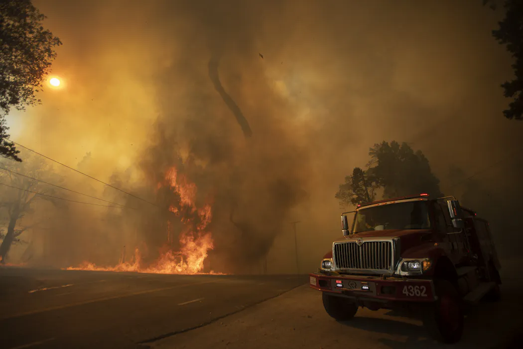
Thick smoke from massive wildfires has been spreading in North America and Europe once again in 2026. The health impacts of breathing this particle-filled air are becoming well known, but wildfires’ influence on the weather is less widely recognized.
We often think about weather controlling wildfires: Dry air, heat, wind and lightning determine when fires start and how quickly they spread. However, once a wildfire becomes intense enough, the relationship can flip. Instead of simply responding to the weather, the fire begins to create its own weather.
I study wildfires and air quality at the University of Texas at Arlington. Here are four key ways wildfires influence the weather around them:
1. Updrafts and fire tornadoes
Wildfires release a large amount of heat. As the air above the flames heats up rapidly, it becomes lighter than the surrounding air. As a result, the warm air rises.
This upward motion creates a powerful current of air known as an updraft. In some cases, the rising air becomes so strong that it begins to spin, forming a fire whirl, also known as a fire tornado.

The process is very similar to how a typical tornado forms, though fire tornadoes tend to be smaller and, because they feed off the heat, confined to the fire area.
2. Fire clouds and thunderstorms
The rising plume of smoke and hot gases also contains water vapor released from burning vegetation and the surrounding atmosphere. As the plume rises, the water vapor cools and condenses into tiny cloud droplets, forming a cloud directly above the fire.
Scientists call these clouds pyrocumulus, or fire clouds.

As water vapor condenses, it releases additional heat, making the rising air even more buoyant. If the fire is intense enough and the atmosphere is unstable, the cloud can continue expanding upward into the upper troposphere. It may eventually develop into a pyrocumulonimbus cloud – a thunderstorm generated by the fire itself.
3. Fire-generated lightning
As the pyrocumulus cloud rises above the point in the atmosphere where the air temperature drops below freezing, cloud droplets begin to freeze, producing ice crystals, supercooled water droplets and graupel – a soft version of hail.
Collisions among these particles separate positive and negative electric charges within the cloud. Over time, the charge imbalance becomes strong enough to produce lightning.
Some of these lightning strikes can ignite new fires beyond the original fire perimeter, making firefighters’ jobs even harder.

In late July 2026, a severe wildfire near Saumos in southwestern France became intense enough to generate a pyrocumulonimbus cloud. Lightning from the storm ignited new fires outside the original burn area, allowing the fire to spread beyond its initial blaze.
4. Smoke can change weather downwind
Wildfire smoke can also affect weather far from the flames. Smoke can travel hundreds or even thousands of miles. Along the way, it can influence how clouds form and how lightning develops.
Smoke contains large numbers of tiny particles. These particles act as seeds on which water vapor condenses to form cloud droplets. Scientists call these seeds cloud condensation nuclei. When wildfire smoke arrives over a region, it increases the number of cloud condensation nuclei in the atmosphere. As a result, the same amount of water is divided among many more cloud droplets, making each droplet smaller.
Smaller droplets take longer to merge into raindrops, which can delay rainfall or shift it to another location downwind. This is one reason why forecasting precipitation becomes more challenging during major wildfire events.
Scientists have also found that wildfire smoke can alter lightning patterns in downwind thunderstorms.
Under normal conditions, about 90% of cloud-to-ground lightning carries a negative charge, while positive-charge cloud-to-ground lightning is relatively rare. However, studies have reported unusually large numbers of positive-charge lightning strikes in smoke-affected storms.
Positive lightning is more powerful and damaging than negative lightning. It carries larger electrical currents, lasts longer and releases more energy. As a result, it is more likely to ignite new wildfires and can pose greater risks to people and infrastructure.
In some smoke-affected thunderstorms, positive flashes accounted for more than 40% of all cloud-to-ground lightning. In the most extreme cases, the fraction exceeded 90%, meaning that nearly all cloud-to-ground lightning was positively charged.
Living with fire and its consequences
The next time wildfire smoke turns the sky hazy, remember that the smoke is not simply drifting through the atmosphere – it is becoming part of the atmosphere.
Wildfires and their smoke can shape clouds, rainfall and lightning in ways we are only beginning to understand. As large wildfires become more frequent, living with them will require more than fighting fires. We must also learn to anticipate and adapt to their far-reaching effects on air quality, health and even the weather.
Yunyao Li does not work for, consult, own shares in or receive funding from any company or organization that would benefit from this article, and has disclosed no relevant affiliations beyond their academic appointment.
Read These Next

Many drugs have mirror chemical structures, one helpful and the other harmful – a Nobel-winning disc
From thalidomide to resveratrol, molecules with the exact same chemical properties can have drastically…

From jargon to impact: Teaching undergraduates the art of public communication
Teaching public storytelling to students can help them communicate better in the world.

Why your boss matters more than remote or hybrid work when it comes to burnout and job satisfaction
A return to the office can mean very different things to different workers, which is why this debate…