Better urban design could help save Florida’s threatened Big Cypress fox squirrel
The Big Cypress fox squirrel is losing its habitat to urban and suburban development. But a few design changes could help to save this and other species.

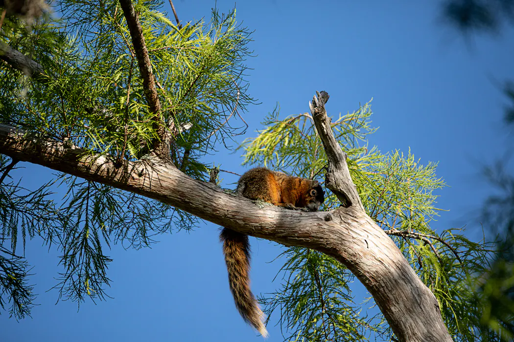
Florida is home to a host of diverse wildlife you can’t find anywhere else. Most people know of manatees and Florida panthers. But you might never have heard of the Big Cypress fox squirrel, a subspecies found only in southwest Florida.
At up to 2 feet, 3 inches (68.5 centimeters) long, including its tail, and weighing roughly 3 pounds (1.36 kilograms), the Big Cypress fox squirrel is a heavyweight compared with its cousin, the eastern gray squirrel. But while gray squirrels can thrive across much of the eastern U.S. and Canada, the Big Cypress fox squirrel’s habitat is limited to five Florida counties south of the Caloosahatchee River.
This means every new road, canal and subdivision takes a bigger bite out of its world.
Because this squirrel is so shy and hard to spot, no one knows how many remain, which is one reason the state of Florida lists it as threatened. Historically, it moved through cypress swamps, pine savannas and hardwood forests. But these days, it often navigates a patchwork of golf courses, parks and low-density neighborhoods, crossing open lawns and scattered tree canopies to reach safe cover.
As the links between habitable areas disappear, Big Cypress fox squirrels are funneled into a few risky travel routes. This can cause their populations to become isolated from each other and more vulnerable to decline.
As a landscape conservation researcher, I study how wildlife moves through changing environments and how urban design can support that movement. My most recent research, in collaboration with colleagues from the University of Florida and Florida State University, focused on the Big Cypress fox squirrel. Our team asked one practical question: How can city planning and landscape design support wildlife movement as the region grows?
A new approach
What’s new about our work is that we paired connectivity modeling – a method that maps how easily animals can move across a landscape – with an approach to urban design that organizes landscapes along a gradient from dense urban areas to natural habitats. This approach helps planners match conservation strategies to each setting, or transect zone – urban, suburban, seminatural, such as parks and golf courses, and core habitat, or undisturbed areas.

Our method is unique because it integrates wildlife connectivity data directly into actionable design solutions for each zone, rather than proposing a single corridor. This allows planners to design landscapes that support wildlife movement in ways that can be replicated anywhere. In suburban neighborhoods, for example, wildlife crossings and native plants provide safer movement options.
Importantly, this approach is not specific to preserving just this species of squirrel. Planners and conservationists can use it to maintain wildlife movement alongside development across Florida and beyond. This includes other priority areas along the Florida Wildlife Corridor where development constrains animal movement.
To develop our approach, we used habitat suitability models developed by the Florida Fish and Wildlife Conservation Commission using detailed land-cover data and verified squirrel observation records kept by Florida Natural Areas Inventory and universities in Florida and Arizona. Then we converted this data into what landscape conservationists call a resistance map, which shows how difficult it is for a Big Cypress fox squirrel to move across the landscape.
We applied the model across the squirrel’s known range in southwest Florida, with a focus on rapidly developing areas around Fort Myers and Naples. We then identified where movement is concentrated and where it gets squeezed into narrow pathways.

Squeezing through ‘pinch points’
Our model showed that the squirrel’s best habitat persists in a network of pinch points, bottlenecks where development and infrastructure funnel movement into a limited set of pathways.
In the broader southwestern Florida region, those bottlenecks show up near urbanizing areas such as Naples, Fort Myers and Bonita Springs. In Fort Myers, for example, squirrel movement was funneled into just a few narrow routes, such as urban parks in highly developed areas and less developed spaces such as golf courses and residential neighborhoods with tree cover. Movement was more diffuse near wetlands and along the Caloosahatchee River.
This means that even in built-up areas, a few connected strips of trees, water edges and open space make a big difference, because they may be the only workable routes left.
We also found that many important habitat patches and connections fall outside protected areas. Rather, they lie on private and intensively managed lands, such as residential yards, golf courses, agriculture and landscaped spaces that are regularly maintained. In fast-growing southwestern Florida, that means long-term conservation depends not only on preserves but also on how neighborhoods, road projects, parks, golf courses and vacant lots are planned and maintained.

From wildlife science to real-world design
Instead of creating just one wildlife corridor, we design solutions for different types of landscapes along a city-to-nature gradient. From dense urban areas to natural habitats, this lets us keep the landscape connected using a network of green infrastructure while matching conservation actions to how the land is used and how squirrels are likely to move through it.
In urban and suburban areas, squirrels are using the remaining open spaces, such as parks and low-density residential areas, but these landscapes can function as ecological traps as well as population “sinks,” where risks such as vehicle collisions are higher.
Roads, highways and railroad tracks are major sources of habitat fragmentation and wildlife mortality, so one priority is to make it safer for wildlife to cross.
Our study proposes canopy bridges and other wildlife crossings. Other helpful measures include traffic-calming strategies, signage and “green street” design, which integrates vegetation, stormwater management and safer road layouts to reduce risks for both wildlife and people.
We also propose retrofitting existing infrastructure in urban areas with elements such as green roofs, living walls, bioswales – channels that help keep stormwater clean – rain gardens and permeable pavement. These features add vegetation, absorb stormwater and reduce heat, while also making urban areas easier for wildlife to navigate.
In suburban areas, priorities include planting native vegetation in yards, parks and roadside buffers and improving road crossings where animals are most at risk.
In seminatural areas such as golf courses, opportunities include restoring native vegetation and maintaining “stepping stone” habitats. These are small patches, such as tree clusters and bushes, that animals can use as safe stopovers while moving across developed landscapes.
This kind of green infrastructure can reduce flooding, improve water quality, lower urban temperatures and create recreational spaces – benefits that support both wildlife and the people who live alongside them.
Eve Bohnett does not work for, consult, own shares in or receive funding from any company or organization that would benefit from this article, and has disclosed no relevant affiliations beyond their academic appointment.
Read These Next

Republicans control Congress, so why is Trump’s SAVE America Act stuck?
Republicans hold both chambers and publicly back the president’s signature bill that would curtail…

Autistic children drown at alarming rates - swim lessons and water safety strategies can save their
Water activities provide a refreshing escape from the heat, but without proper safety precautions, they…
Autocracies get more repressive when opening up their economies – a political scientists explores wh
Economic globalization was supposed to encourage democracy around the world. But sometimes the opposite…