Winter’s alarmingly low snowpack offers a glimpse of the changing rhythm of water in the western US
Streamflows the West relies on for drinking water and farms used to follow a fairly predictable arc as winter snow melted. Rising temperatures are changing that.

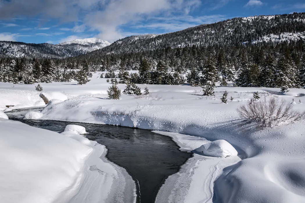
Winter is more than just a season in the western U.S. – it is a savings account to get farms and homes through the long, dry summer ahead. As the snowpack that accumulates in the mountains through winter slowly melts in late spring and summer, it feeds into rivers and reservoirs that keep communities and ecosystems functioning.
The April 1 snowpack measurement has long been the single most important number in western water management, considered a strong proxy for how much water the mountains are holding in reserve.
But in 2026, that savings account has been woefully deficient.
Across the western United States, temperatures from November through February were among the warmest on record, with many areas 5 to 10 degrees Fahrenheit (2.8 to 5.5 degrees Celsius) above the 20th-century average. March continued to break heat records. At lower elevations, the higher temperatures meant a significant part of the winter’s precipitation fell as rain rather than snow. In some places, snowfall accumulated but melted quickly during warm periods.

As a result, even regions that received near- or above-normal precipitation for the season failed to build substantial snowpack. In the northern Rockies and the mountains of the Pacific Northwest, any above-average snow accumulation was largely confined to the highest elevations, while middle and lower elevations had relatively little snowpack.
This situation is a hallmark of warming winters. As global temperatures rise, the freezing line where precipitation changes from rain to snow moves up the mountains, shrinking the area capable of sustaining a seasonal snowpack.


The exceptionally warm winter of 2025–26 across much of the western U.S. delivered a powerful preview of what the regional water cycle in a warmer climate may increasingly look like: less snow and a fundamental reshaping of the hydrograph – the chart of how much water flows through streams across the year.
A flattening hydrologic pulse
The consequences of this shift for water supplies are already visible in streamflows.
In multiple river basins in the West, streamflows were above average in winter and early spring, and some locations were approaching record-high levels. Historically, that water would have remained frozen in the snowpack until late spring. Instead, precipitation arriving as rain – along with intermittent midwinter melting events – increased the runoff.
Scientists who study natural water flows, as I do, pay attention to the hydrographs of streamflows in river basins to see when the water flow in mountain streams is strongest and how long that flow is likely to continue into summer.

In recent years, rising temperatures have led to a redistribution of streamflows throughout the winter and early spring in ways that are fundamentally reshaping the hydrographs of snowmelt-dominated rivers. Rather than a single dominant peak during late spring or early summer, smaller peaks emerge in winter and early spring. At the same time, the traditional snowmelt pulse, relied on to fill reservoirs in late spring, weakens.
In effect, the hydrograph is flattening. The winter of 2025–26 illustrates this phenomenon: Higher early-season streamflows suggest the West will see less runoff later in the year when communities, farms and wildlife need it.
The Colorado River: A system on the edge
Nowhere does the convergence of record warmth, depleted snowpack and altered hydrology carry higher stakes than in the Colorado River Basin. More than 40 million people in seven states plus Mexico and 5.5 million acres of farmland depend on the river’s water, but the river’s flow is no longer meeting demand.
The April-through-July 2026 runoff into Lake Powell – the reservoir behind Glen Canyon Dam and the primary index of the Upper Colorado River Basin’s annual water budget – is currently forecast to rank among the lowest in recent decades. It has been tracking close to the grim years of 2002 and 2021, considered benchmarks of western drought.
Unless spring brings substantial late-season snowfall to the high mountains, 2026 could join those years as a marker of how thin the margin between water supply and demand has become in a river system already under sustained stress from two decades of drought and water overuse.
The low reservoir levels in the basin in 2026 and the low snowpack are adding fears of water shortages just as the seven states that rely on the Colorado River are struggling to reach a new water use agreement.
The changing rhythm of water in the West
The winter of 2025–26 highlights two emerging realities.
First, temperature is increasingly dominating precipitation in determining western water supplies. Even above-normal precipitation cannot compensate for persistent warmth when it falls as rain rather than snow and accelerates snowmelt in the mountains.
Second, the nature of the West’s streamflows is shifting in ways that complicate water management.
Rain-on-snow events can produce flooding in winter, as the Seattle area saw in late December 2025. A low snowpack also means less runoff in summer, which can exacerbate water shortages and raise the wildfire risk as landscapes dry out. Even if a year has normal precipitation, if it falls as rain or there is earlier snowmelt, then evaporation through summer, in a warmer climate, will leave less water in the system.
Snowpack declines, earlier runoff, elevated winter flows and flattened hydrographs are all consistent with long-standing projections for the western United States as global temperatures rise.
What makes the winter of 2025-26 notable is how clearly these signals appeared, even in a year without widespread precipitation deficits.
This shift highlights the need for adaptive reservoir operations – the ability to adjust water storage and release decisions in real time to capture earlier runoff and preserve water for longer dry seasons, while still maintaining space in reservoirs for flood control during wetter winters. For communities across the West, it also reinforces the growing reality that the familiar seasonal rhythm of mountain water is changing.
Imtiaz Rangwala receives funding from USGS, NOAA, NSF and USDA. He is affiliated with Boundless In Motion.
Read These Next

The Catholic principle guiding popes through tech upheavals, from the Industrial Revolution to AI
Pope Leo is one of many popes to respond to technological change by drawing on a Catholic principle…
What this western Pennsylvania ’90s Pizza Hut reveals about nostalgia
A CMU marketing researcher explains why the love of a retro Pizza Hut has more to do with the relationships…

58 years of attacks on the media by powerful leaders trying to deflect criticism, from Nixon to Trum
American faith in news is at an all-time low, aided by a president hostile to the press. But presidents…