Federal money is coming to fix aging flood control systems – but plans all too often reflect histori
As federal funding for infrastructure rolls in, communities run the risk of spending millions of dollars on systems that aren’t built to handle the flood risks ahead.

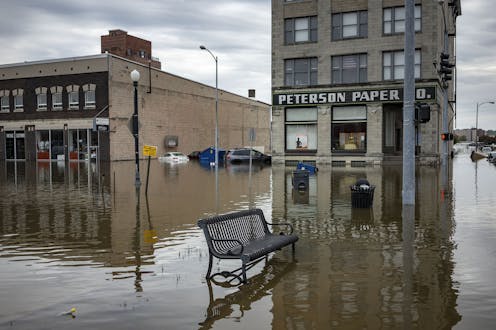
Heavy downpours and a thick snowpack in the Western mountains and Upper Midwest have put communities in several states at risk of flooding this spring – or already under water.
Flooding is the costliest type of natural disaster in the U.S., responsible for about 90% of the damage from natural disasters each year. It happens almost every day somewhere in the country.
Yet, much of the aging infrastructure meant to protect U.S. communities is in bad shape and, in some cases, failing. The American Society of Civil Engineers gave the nation’s dams, levees and stormwater infrastructure a D grade in its latest report card, in 2021.
Help is coming. Congress authorized billions of dollars for infrastructure projects under the Infrastructure Investment and Jobs Act in 2021. But there’s a problem: New infrastructure planning frequently relies on historical flood patterns for its benchmarks rather than forecasts of changing risks as the climate warms.
We study flood risks and mitigation strategies as civil and environmental engineers. As federal funding for infrastructure rolls in, communities run the risk of spending millions of dollars on systems that weren’t built to handle the flood risks ahead.
Infrastructure is failing
Much of the nation’s flood control infrastructure was designed for 20th century storms and flooding. And in many cases, stormwater systems, levees and dams are now approaching the end of their useful life, or are already well beyond it.
The nation’s river levees are 50 years old on average. Retention ponds are meant to last 20-30 years on average. Stormwater systems are also aging, and retrofits in cities like Chicago and Philadelphia are getting expensive.
Midland, Michigan, saw the risks in 2020 when heavy rainfall caused the Edenville Dam, built in 1925, to collapse. The rush of water overwhelmed a second downstream dam, creating a disaster that drained two lakes and damaged or destroyed more than 2,000 homes. The dams’ owner had lost its hydropower license for the Edenville Dam two years earlier, in part for failing to widen its spillway for safety.
Increasing damage like this has pushed federal flood insurance costs higher – more than three times higher in parts of coastal Louisiana and Florida under the Federal Emergency Management Agency’s new risk-based premiums, newly released FEMA data show. At the same time, many of the people most at risk are low-income families who can least afford the costs of recovery without help.
Old data won’t protect against future flood risk
The Infrastructure Investment and Jobs Act, the most significant U.S. infrastructure law in recent years, includes $55 billion in new spending for water infrastructure – money that is making its way to communities. But that’s barely an eighth of what the American Society of Civil Engineers estimates is needed for drinking water, wastewater and stormwater infrastructure improvements.
And another problem arises when the money arrives.
Often, new infrastructure is designed using historical data, such as past high-water marks and storm intensity, to determine future flood risk. However, climate change is moving those baselines.
Years of satellite observations have shown that, globally, both extreme wet and extreme dry conditions have increased in extent, duration and severity. A warming atmosphere can hold more moisture, leading to stronger downpours. As heavy precipitation intensifies, more frequent and severe flooding events have hit the U.S.
The Federal Emergency Management Agency currently estimates that approximately 13 million Americans – around 4% of the population – live in 100-year flood zones, meaning the area has at least a 1% chance of flooding in a given year. But FEMA’s maps often overlook smaller streams that frequently run through heavily populated areas.
Federal flood maps also take years to update. Many still rely on decades-old data and fail to consider the rising risks from climate change. That can lead to complacency for community leaders and residents – until it’s too late.
There are alternatives that communities can use to help align their planning with a more likely future.
Researchers working with the nonprofit First Street Foundation developed some of the first U.S. flood maps that account for future flood risk at the local level. They estimate that climate change alone will increase flood damage in the U.S. by 26% by 2050 and expand into areas that rarely saw severe flooding in the past. With people continuing to build in high-risk areas, the costs and number of people at risk rise even higher.
What can communities do?
Protecting communities starts with changing the status quo, including incorporating climate change into infrastructure planning and developing innovative policies for better flood management.
Stopping construction of new homes in flood-prone areas can help avoid future damage and the need for expensive infrastructure, though political pressure and housing shortages can make these measures difficult.
Buyouts of flood-prone homes to prevent rebuilding are expensive and slow, but they have been used in over 1,100 counties in almost every state to avoid repeated flooding. In some cases, moving away from coastlines and riversides is the only option. Known as managed retreat, it is gaining interest, particularly in communities at risk from sea level rise, but it’s also controversial. Success largely depends on whether the effort is community-led.
Nature-based solutions, such as bioswales, wetlands and rain gardens, can be relatively affordable methods to help capture and absorb rainwater, reducing the amount of runoff that flows into rivers and exacerbates flooding.
But for many communities to remain unchanged, building and maintaining large-scale infrastructure will be necessary. Designing structures like levees or seawalls so they can be expanded or raised in the future is one strategy that can ultimately save money.
Innovative and sustainable funding mechanisms will likely be needed to support flood resilience efforts. One option is establishing local dedicated funds to finance flood resilience initiatives, supported by government grants, private donations and small local taxes. Managed well, these funds could invest in long-term solutions and sustainable land practices that can reduce the frequency and severity of flooding.
Many communities are making an effort, often pushed by residents lobbying officials to prioritize flood initiatives and investments designed to stand up to the future. Changes won’t happen overnight, but taking proactive measures and supporting innovative solutions will benefit communities in the long run and is the fiscally responsible thing to do.
The authors do not work for, consult, own shares in or receive funding from any company or organisation that would benefit from this article, and have disclosed no relevant affiliations beyond their academic appointment.
Read These Next

‘Heartstopper’ is helping LGBTQ+ fans find hope and community across time and space
Stories about young queer people coming of age and finding love have touched people across age and identity,…

What does it mean to be ‘quantum’? A physicist explains the basics behind Einstein’s spooky actions
Particles’ properties at the quantum level could one day enable faster computing and better cybersecurity.

How to be grateful to someone – even when you really don’t want to
Struggling to feel grateful? Try thinking differently about what caused the person’s actions.